Updates to Rural and Urban Areas Based on the 2020 Census
Earlier this year, the U.S. Census Bureau released updated boundaries for urban areas based on the 2020 census. These definitions are widely used by analysts, researchers, and government agencies. Federal agencies like the U.S. Department of Agriculture and the U.S. Department of Education incorporate the designations into their own urban-rural classifications. The U.S. Department of Transportation and U.S. Department of Housing and Urban Development use census-based classifications in their funding formulas and to make decisions about program eligibility. This post examines the U.S. Census Bureau's 2020 urban delineations and explores how they shift the urban-rural distribution in the Fifth District.
What Qualifies as Urban in the 2020 Census?
According to the Census Bureau's updated definition, a census urban area comprises "a densely settled core of census blocks that meet minimum housing unit density requirements, along with adjacent territory containing non-residential urban land uses as well as territory with low population density included to link outlying densely settled territory with the densely settled core." The Census Bureau periodically evaluates its urban delineation criteria and makes changes to account for shifting urbanization patterns. In preparation for releasing 2020 census data, the Census Bureau proposed changes to the urban delineation criteria that were used for the 2010 census. After a public comment period, the Census Bureau outlined the final criteria and all 2020 urban areas in the Federal Register in December 2022.
One major change to the criteria is the adoption of a housing unit density threshold to determine whether a particular census block (the smallest unit of census geography) is included in an urban area. In 2010, urban designation was based on population density. However, now the Census Bureau argues that the number of housing units per square mile, rather than people per square mile, is a more accurate depiction of urban concentrations. In 2020, the Census Bureau required a housing density of 425 units per square mile for a block to be included in an urban area.
A second major change is an increase in the population threshold requirement for an urban area. In 2010, and otherwise since 1910, an area needed a minimum population of 2,500 residents to qualify as urban. In 2020, an area needed 5,000 residents or 2,000 housing units. The addition of a housing unit threshold is to provide flexibility for communities. For example, seasonal communities with a lower population on April 1 but are densely developed could qualify as urban using the housing threshold rather than the population threshold.
A third major change is the elimination of the two subcategories of urban areas used in 2010. Rather than distinguishing between urbanized areas (urban areas with a population of at least 50,000) and urban clusters (urban areas with population greater than 2,500 but less than 50,000), the Census Bureau refers to all urban areas, regardless of size, as "urban areas." In the Fifth District, urban areas range in size significantly: Fifth District urban areas include the Washington-Arlington-Alexandria metro area (population 5.1 million) and part of Tazewell County in Southwest Virginia (population 4,666).
How Does the Rural-Urban Population Distribution Look Under the New Criteria?
The Census Bureau uses these criteria to distinguish rural and urban areas; any area not included in a designated urban area is considered rural. The Census Bureau identified 2,612 urban areas in 2020 (including 36 new urban areas) compared to 3,573 urban areas in 2010 under the previous criteria. This resulted in a 2.4 percent increase in rural land area in the United States.
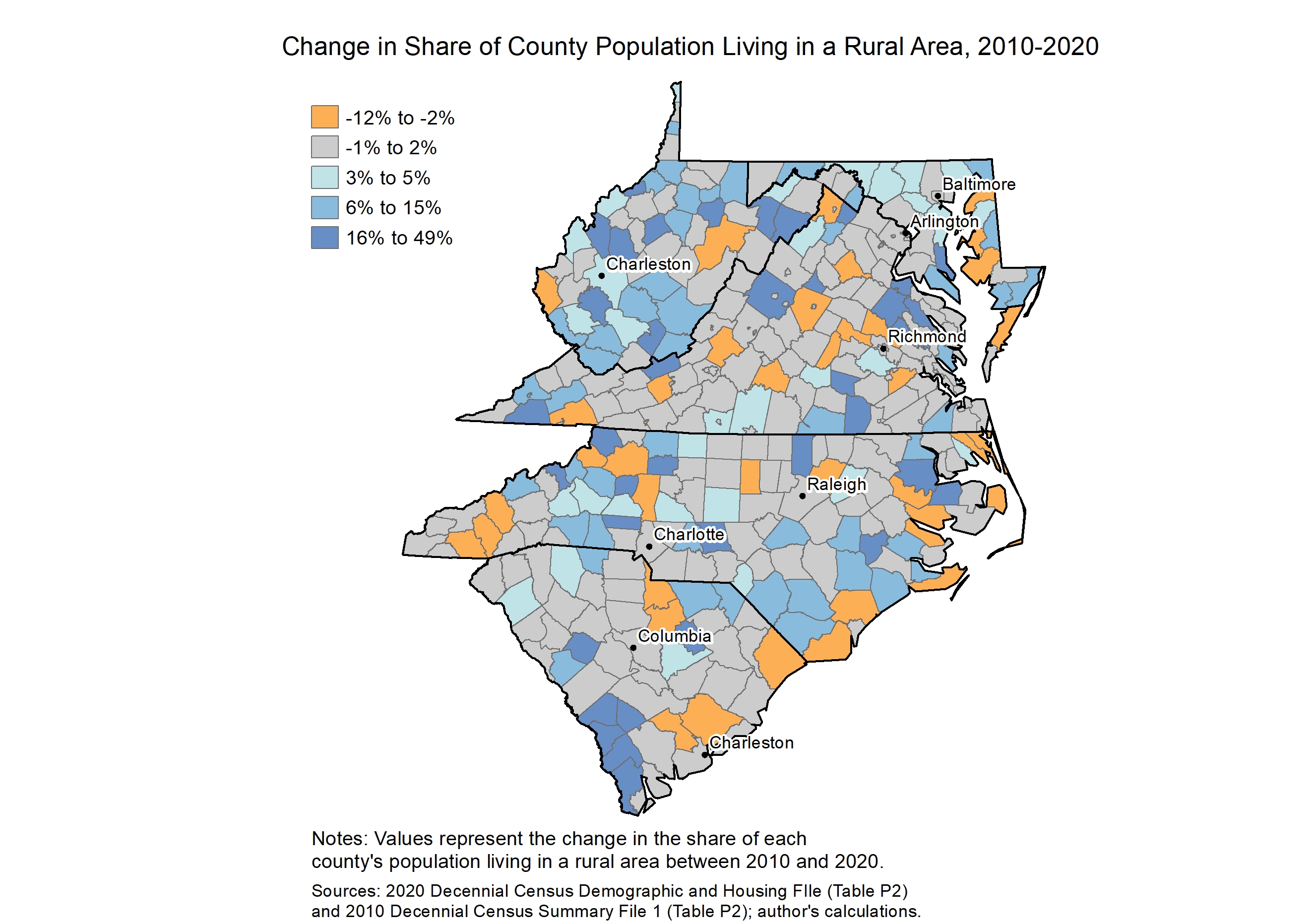
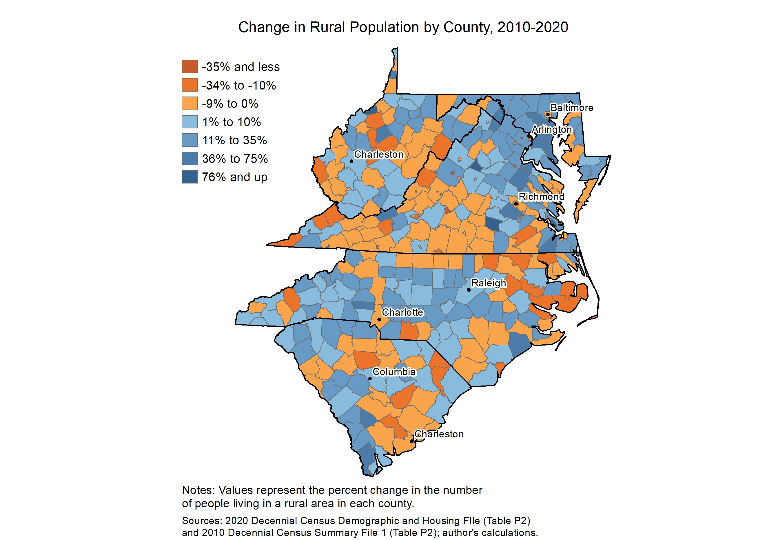
Nationally, 20 percent of the population lived in a rural area in 2020, representing a slight increase from the 19.3 percent in 2010. The rural population increased by 11.4 percent between 2010 and 2020, while the overall U.S. population grew 6.4 percent. In the Fifth District, 9.1 million residents, or 27.7 percent of the population outside of the District of Columbia, lived in a rural area in 2020. The rural population increased by 7.8 percent between 2010 and 2020, but like the nation overall, the share of the population living in a rural area stayed roughly the same. Among Fifth District states, West Virginia and Maryland saw increases in the share of population in rural areas.
Each state in the district experienced an increase in population living in rural areas. West Virginia's rural population increased, but the state's population decreased overall. (See chart.) Notably, there were four new urban areas added in the Fifth District: Blowing Rock, North Carolina; Lake Royale, North Carolina; Chincoteague on the Eastern Shore in Virginia; and Seabrook Island in South Carolina.
What's Behind the Rise in Rural Population?
The change in the rural-urban distribution in the United States and the district is largely due to the changes to Census Bureau criteria rather than a broad shift toward rural migration. The higher required population thresholds and housing unit density requirements for urban areas are driving increases in rural population. In 2010, 102 Census Bureau urban areas that lie completely or partially within Fifth District states would have been classified as rural rather than urban under the new population and household thresholds. In other words, 385,676 urban residents in Fifth District states would have been classified as living in a rural area in 2010 had the 2020 urban area criteria been applied.
Still, the reclassification of previously urban areas may more accurately reflect the presence of rural challenges and opportunities in those places. Forty-one counties in the Fifth District became completely rural in 2020 after previous urban areas were reclassified, including four counties that were more than 40 percent urban in 2010. For example, the 2010 urban cluster in Allendale County, South Carolina, was eliminated following the 2020 census. The cluster, which primarily included the town of Allendale, had a population of 3,307 in 2010 over 2.3 square miles, which accounted for all the county's urban population. Along with the shift to a completely rural population, Allendale County's population declined by 23 percent overall.
Aside from purely reclassification effects, population increases in census rural areas also reflect broader trends in the district's growth. Most of this growth is in counties that are in or adjacent to large metropolitan areas including Charlotte, Raleigh, Richmond, and Washington, D.C. The rural population in Johnston County bordering Wake County, which includes the state's capital city of Raleigh, increased by 26,609 between 2010 and 2020. The county also added more than 20,000 urban residents over the same period. Loudoun County, a growing exurb bordering Fairfax County in Northern Virginia, saw a 27.8 percent increase in the rural population despite a decrease in the land area classified as rural. The total population in Loudoun County increased by 35 percent over the same period. There were 51 counties in the Fifth District for which the increase in rural population coincided with an increase in the urban population. Forty-four of these counties are in metropolitan areas.
Looking Ahead
Even though the Census Bureau releases annual county-level population estimates that offer insight into the components of population change (for example, see "Shifting Populations: Results from 2021 Census Estimates") the 2020 urban area designations will have lasting implications for communities and warrant careful attention. Changes in urban-rural population may affect federal funding amounts and program eligibility. As agencies incorporate new census designations into their funding formulas and rural-urban classifications, it will be important to watch for shifts in status and eligibility.


