Skip to Main Content

The Urban Core in the Tale of Three Cities

Econ Focus
Second Quarter 2017
District Digest

The Fifth District economy — like the U.S. economy — is increasingly driven by urban areas. In 2016, over 90 percent of U.S. gross domestic product (GDP) was attributable to metropolitan statistical areas, or MSAs, while they occupied just under 50 percent of the nation's land mass. This is not a new phenomenon, but it remains an important one. There is a long history of literature that aims to understand how and why cities develop and the opportunities and constraints faced by firms and households in that development. In addition, the contraction of certain cities in the past few decades (such as Detroit, Cleveland, and Pittsburgh) has puzzled economists and spurred interest in better understanding how and why cities contract.

The economic importance of urban areas in the Fifth District is no different from that in the United States as a whole. In 2015, over 75 percent of the Fifth District population lived in metro areas that generated over 90 percent of economic output. This article will start to disentangle the economic literature on the existence, growth, and decline of cities in the context of three very different cities in the Fifth District: Baltimore, Md., Charlotte, N.C., and Richmond, Va. In addition to being home to the three physical branches of the Richmond Fed, these three metro areas account for over 20 percent of the Fifth District's population and close to a quarter of its GDP. And although these three urban areas cannot compete with the economic power of Washington, D.C., in the Fifth District, they are arguably more typical in the forces that affect their economic trajectories; perhaps the differences and similarities among them can cast some light on the forces that affect cities in general.

What does "Urban" Mean?

When most people think of an urban area, the first thing that comes to mind is a city like New York, Tokyo, or San Francisco — tall buildings, high population density, and crowded public transportation. Others may think of cities such as Richmond or Baltimore: slightly less dense, fewer high-rise buildings, but still with small plots for houses, sidewalks for walking, and cars crowding at traffic lights. Those images are of urban cores, but very often, the available data that we have to describe urban areas are at the level of the MSA, which is often a much larger territory than the urban area. (See "Location, Location, Location: The economic differences between rural and metro areas in the Fifth District," Region Focus, Fall 2009.)

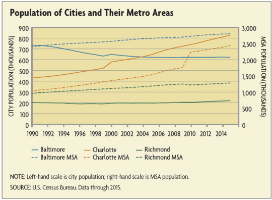
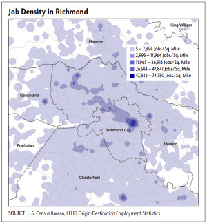
Compared to an MSA as a whole, the urban core of an MSA better fits our vision of a city: Louisa County, for example, which is part of the Richmond metro area, has a population density of about 67 people and 33 housing units per square mile compared to almost 3,500 people (and over 1,600 housing units) per square mile in the city of Richmond (and compared to almost 70,000 people and over 37,000 housing units per square mile on Manhattan). The distinction between central cities and metro areas is important in social and economic outcomes as well. The Richmond MSA, for example, has a little under 1.3 million residents while the city of Richmond has about 225,000 residents. Meanwhile, the unemployment rate for the MSA as a whole was 4.1 percent in 2016 compared to 4.6 percent for the city of Richmond. The numbers in Baltimore are even starker: The unemployment rate in the city was 6.3 percent in 2016 compared to 4.4 percent in the metro area. In Baltimore City, almost 24 percent of people live below the poverty rate compared to about 11 percent in the broader metro area.

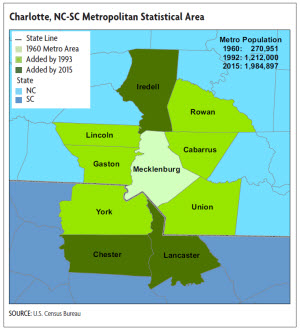
The physical footprints of most metro areas have expanded over time. The growth of the Charlotte MSA from 1960 to today — it is now multiple times its initial size — exemplifies this expansion. (See map below.) The concept of a metro area is based on a large population nucleus with surrounding communities that have a high degree of social and economic integration with that nucleus. For a county to be a part of an MSA, at least 25 percent of the workers living in that county have to work in the central county (or counties) of the metro area, or at least 25 percent of the employment in that county must be accounted for by workers who reside in the central county — like a reverse commute. (There are urbanization/population requirements to be considered a central county or counties.) Therefore, the growth of metro areas is not just about population growth or rising density of economic activity in the expanding periphery; it is also about how many people commute to an urban core. Commuting patterns and availability of transportation then become critical to understanding changes in urban areas.

Why Do Cities Exist?

Cities arise because there are advantages to concentrating economic activity in one place, what economists call agglomeration economies. When businesses in the same industry cluster, they can benefit, for example, from sharing inputs, such as intermediate manufactured goods or skilled labor. Agglomeration economies are how we end up with a technology hub in Silicon Valley, a concentration of carmakers in Detroit, or even a textile district in New York City. Firms can also benefit from the knowledge spillover that occurs from more people living and working in close proximity; in other words, new ideas spread more easily with a concentration of people and businesses. In addition, there is an infrastructure that arises around cities that all industries can benefit from, such as transportation networks, banking, and legal services. In this way, economic development can beget economic development. For example, one of the most compelling arguments for locating a Federal Reserve Bank in Richmond in 1914 was to take advantage of its existing transportation and banking infrastructure.

The development of the manufacturing hub of Baltimore is a good example of these agglomeration economies. First, the city benefited from the port and then from the railroad built in the mid-19th century and the telegraph line that soon accompanied the railroad. The advent of steam power enabled new industries to be built closer to the harbor, and by the 1880s Baltimore had become America's leader in canned fruits and vegetables and a major producer of fertilizer. Baltimore also became a leader in manufacturing chrome, copper, and most importantly, steel. At the turn of the 19th century, the Pennsylvania Steel Company had become so prosperous that it was running out of the raw material to make its steel and therefore turned to ore stores in Cuba. To process the ore into steel, a plant was built on a nearly deserted marshland in Baltimore called Sparrows Point. (See "Red Skies and Blue Collars," Econ Focus, First Quarter 2013.)

From railroads, bridges, and equipment to automobiles and tin cans, the steel industry grew considerably through the early 20th century, and Baltimore grew along with it. From 1900 to 1939, the number of housing units in northeast Baltimore grew from 279 units to over 14,000 units. But then the subsequent decline of manufacturing in the city of Baltimore has created challenges for residents and city officials alike. According to a 2000 book chapter by Marc Levine of the University Wisconsin-Milwaukee, between 1950 and 1995, the city of Baltimore lost 74.9 percent of its industrial base of manufacturing jobs. The city's population peaked at 950,000 residents in 1950 with over 34 percent of the labor force employed in manufacturing. By 1995 only 8 percent of the city jobs were in manufacturing.

Richmond's development also relied on agglomeration economies, particularly surrounding the tobacco industry, iron foundries, and flour mills. According to the 1994 book At the Falls by historian Marie Tyler-McGraw, all three of these industries reached their peak of profitability just before the Civil War. (A fourth major industry of the city, the slave trade, also reached its peak at this time.) Even after World War II, tobacco, in particular, remained Richmond's primary industry and major employer for almost a generation. But there was other manufacturing, too: paper and paper products, iron, and steel among them.

The population outside of Richmond's central city grew by 24.3 percent in the 1960s. After World War II, the population of Richmond continued to grow, with the local economy continuing to offer a good supply of low-to-moderate income jobs. Much of the outward spread of Richmond in the late 1940s and 1950s was the movement of working-class and moderate-income families from central Richmond to brick homes at the edge of the city or just beyond its borders.

The evolution of Charlotte is a little different in that it was never a stronghold of manufacturing activity and it is not on a major body of water and therefore could not rely on port activity. The growing of cotton in the South did engender cotton and textile mill activity in Charlotte, and by the early 1900s about 300 mills had been built within 100 miles of Charlotte; the cotton, combined with J.P. Morgan's Southern Railway, contributed to Charlotte's growth. Nonetheless, the city's population was still dwarfed by those of Baltimore and Richmond: The population of Charlotte reached 82,000 by 1930. This textile heritage was certainly important in the development of Charlotte, and although the industry itself is a fraction of its former size, its legacy remains in driving the emergence of ancillary industry, such as banking, that later drove the transition to a postindustrial economy.

So although manufacturing continues to be an important part of the Charlotte economy, the transportation (such as railways in the early days and later the hub airport) and banking sectors that emerged in the 1980s and 1990s drove continued growth in the Charlotte region. Unlike Baltimore, instead of losing residents in the last 60 years, the city of Charlotte has grown along with its surrounding counties. (See chart below.)

The Central Business District

As firms cluster, they create an area of concentrated economic activity, often referred to as an urban core or a central business district (CBD). The trade-off that households face, then, results in the ring of residential and economic activity that surrounds that CBD. For households, although commuting costs are lower close to work, housing is more expensive, so people might choose to live farther away to get more land. (Of course, house prices will also reflect features such as the quality of schools, access to parks, and crime rates.) In his basic urban land model laid out in his 1964 book Location and Land Use — which has been a basis for much of urban economics — William Alonso modeled a city with a single center where the CBD is home to all of the jobs and the space surrounding the CBD is used for residential purposes. Of course, this is overly simplified: Job density across Richmond, Baltimore, and Charlotte (as in most cities) reflects that these areas have multiple urban cores. In Richmond, for example, there is a concentration of jobs in the downtown area, but also in the western and southern part of the region. (See map below.) To build upon the single-center model, economists have used both traditional methods to model multiple employment centers and some new empirical methods that have been enabled by developments in the trade literature as well as the increasing granularity of available data. In work published in the Federal Reserve Bank of Richmond Economic Quarterly, Richmond Fed economists Sonya Ravindranath Waddell and Pierre-Daniel Sarte elaborate on these new empirical methods.

It also appears that worker productivity (and therefore average wages) are higher in the more densely populated CBD compared even to the surrounding areas. For example, despite the higher poverty rate of those living in the city of Baltimore, over 52 percent of those who work in the city make more than $3,333 per month and only 17.3 percent make less than $1,250 per month. Compare this to the entire metro area, where just under 47 percent make more than $3,333 per month and 22.5 percent make less than $1,250 per month. The differences are just as stark, if not more so, in the Richmond and Charlotte metro areas. 

In most U.S. cities, wealthier households tend to live farther away from the city center (with some notable exceptions), perhaps because wealthier households prefer to occupy more land — although as the household continues to gain wealth, it might move back to avoid spending time commuting. That's why both very poor people and very rich people are often concentrated in city centers.

Of course, there are both other benefits to city living (concentrations of people make amenities such as restaurants and theaters commercially viable) and other costs to city living. It is the costs that prevent cities from unlimited growth. For example, higher density brings congestion and a higher cost of land.

The Rise and Decline of the Urban Core

In the city of Detroit, large declines in population have led to a structure that violates the most basic principle of urban economics: that residents minimize commuting costs. Downtown Detroit, which has a healthy number of employers and employees, is surrounded by a ring of vacant neighborhoods. In a 2017 National Bureau of Economic Research working paper, Raymond Owens and Pierre-Daniel Sarte of the Richmond Fed and Esteban Rossi-Hansberg of Princeton University argued that this is a coordination problem: No resident wants to be the first to move into, and no developer wants to be the first to invest in, a vacant neighborhood. As employment fell in manufacturing and some plants moved elsewhere, residential demand and income dropped, which, according to the authors, contributed to the riots in the late 1960s (riots also experienced in Baltimore) that drove the city into a no-development equilibrium. This story of flight from Detroit's close-in neighborhoods seems consistent with that of Baltimore; the decline in the population of Baltimore's urban core occurred at the same time as an expansion of the metro area.

While the lack of public transportation has kept many poorer families in the city core, transportation issues also explain households moving away from it — development of the highway system reduced commuting costs considerably. Certainly, part of the reason for the decline in population in the city of Baltimore is the decline in manufacturing jobs, but commuting has also gone up. Only 33.2 percent of those who are employed in the city of Baltimore live in the city; the rest commute from outside the city. In Richmond, 78 percent of those employed in the city live outside of the city. On the other hand, a smaller share of Charlotte's downtown employment base commutes: Not quite 60 percent (57.6 percent) of workers in the city commute in from the suburbs.

There are other dynamics at play, such as the durability of the housing stock, as discussed by Edward Glaeser and Joseph Gyourko in a 2005 article titled "Urban Decline and Durable Housing" and by Jan Brueckner and Stuart Rosenthal in a 2009 article in the Review of Economics and Statistics. When a city is new, buildings near the CBD are the most desirable, but as those building age and deteriorate, households may move to new developments surrounding the city. These buildings become left to lower-income households. After some time, the deteriorated buildings are redeveloped and higher-income people move back in, causing gentrification. When the population in the city starts to decline, the existing housing stock does not disappear; it can take a long time before it is profitable to refurbish or replace a building. The surplus of housing depresses house prices below the cost of construction, and falling rents may draw lower-skilled and lower-income households into the city, intensifying urban sorting by income.

For example, the city of Baltimore identified 16,636 properties as vacant as of December 2014 (defined as those that have vacant building notices or code violations.) This might be an understatement, since the Census — which defines a vacant building as one that has not had mail delivered for 90 days, counting each unit in an apartment building — identified 46,782 vacant dwelling units in Baltimore in 2010. According to a 2015 report of the Abell Foundation, a Baltimore-based philanthropy, "Baltimore is a city built for one million people but is now only occupied by approximately 620,000. In the four decades since Baltimore began its war on vacant houses, the city lost 31 percent of its population due to massive suburban flight and to staggering losses of manufacturing jobs — with 30,000 people alone losing work at the now shuttered General Motors and Bethlehem Steel plants."

Policy Options and the Role of New Empirical Models

Cities like Baltimore and Detroit are grappling with how to address an aging housing stock and diminished population. Most economists embrace labor mobility; the policy concern is not that workers in the city of Detroit or in the city of Richmond have moved outside of the CBD. Rather, the concern of policy is more for the livelihood of those who are left behind: Cities such as Baltimore and Richmond suffer higher unemployment and poverty rates than the surrounding counties. What is more, agglomeration economies are a powerful reinforcing mechanism for large transformations in a city over time. Perhaps targeted and thoughtful investments could provide a catalyst for these forces where the benefits outweigh the costs. Recent work such as the Owens, Rossi-Hansberg, and Sarte paper on Detroit and a 2015 article in Econometrica by Gabriel Ahlfeldt and Daniel Sturm of the London School of Economics, Stephen Redding of Princeton University, and Nikolaus Wolf of Humboldt University has brought to light a new opportunity to take advances in the international trade literature and the increasingly available granular data to model a city with data. Once a city can be modeled in a realistic way, it is easier to understand the effects of a shock to a city's economy or the likely effects of new policies, such as housing assistance or subsidies of transportation costs.

Richmond, Baltimore, and Charlotte are extremely different cities. They each developed because of a combination of their natural endowments, specific policy goals of local officials, and some catalyst that engendered growth in a particular industry at least in part through agglomeration economies. Richmond benefited from its location close to the James River and the tobacco industry; Baltimore relied on its harbor and the steel industry; and in Charlotte, the political and business leadership brought textile mills, hubs of transportation, and, in the 1980s and 1990s, banking. With the data that are now available on commuting patterns, population, employment, wages, and land values, economists can model each city to better understand the dynamics of urban areas and the possible role of policy. 

Subscribe to Econ Focus

Receive an email notification when Econ Focus is posted online.

Subscribe to Econ Focus

By submitting this form you agree to the Bank's Terms & Conditions and Privacy Notice.

Phone Icon Contact Us

David A. Price (804) 697-8018